Go around
Hi guys.
Someone can give me explanation about go around procedure ?
Especially about fms ,delete no link and after ...
It looks like you're new here. If you want to get involved, click one of these buttons!
Hi guys.
Someone can give me explanation about go around procedure ?
Especially about fms ,delete no link and after ...
Comments
Hello,
maybe this will help you first, I won't be free again until next week.
Hi.
Can you look my video and say me why first try vnav path engage right now when i capture LNAV app and second try VNAV path not engage right now and there is a TOD after IAF ?
Hello, in the first attempt you are already flying with VNAV, i.e. you are in an active descent profile. Thus, after ACT APPR, you continue to decrease with VNAV and a specially calculated VS between MIPOT and DUTKI from 5000 to 4100 and then continue in the final approach until the go around is initiated. In the second attempt you fly with ALT SEL, only with the automatic approach activation (22:30) does the VNAV deviation scale become visible and the current VDEV to the next waypoint DUTKI. In your case, these are partly -2000 ft. The reason is that, unlike the first attempt, VNAV calculates a TOD from the current altitude (5000 ft) in order to use the VS (probably -1800 ft) programmed on the VNAV Page 4100 ft at DUTKI. The Dash would then really have to fly at -1800 ft, where about -500 was flown in the first attempt. Because of this VDEV (afterwards they are clearly too high), VNAV cannot yet become active. VNAV only becomes active when the newly calculated TOD is approached. Since you had previously sunk manually to 4100 ft, you could then also activate VNAV, as the VDEV was now within the permissible range.
I think you shouldn't want to fly VNAV so stringently in every situation. In the case of the Go Around, VNAV will not be programmed again. ATC gives you an amount, or this is initially derived from the GA procedure. In the case of CYEG, an ATC will then lead back towards the IAF and ultimately also release to the altitude at the FAF, i.e. 4100 ft. I would fly that with VS and then activate VNAV in front of the FAF. In the example here you can clearly see that the aircraft at BEMIG at about 16:55 minutes is still well above 5100 ft, but at DUTKI it has about 3600 ft for a VDA / GPA. (In the charts of 2017 DUTKI has 3600 ft for the RNAV Z Rwy 12), the path is cut at 4.5 NM before DUTKI, which is practically the same as your TOD on the GA.
https://www.flightradar24.com/data/flights/ws3416#28405b23
So in your case I would try to drop VS down to the FAF to 3600 and activate VNAV before the FAF. In my charts the distance between DUTKI and Rwy 12 is 3.8 NM with the Majestics 5.9 NM.
When i'm before FAF i'm at FAF altitude i hit vnav button and i get vnav path but plane don't descent.I beleive i must to insert lower altitude.
It is always difficult to judge from a distance and without pictures and without looking back at your actions beforehand. Have you had VNAV armed?
@helico55
Hi,
Yes you should enter a lower altitude than your present altitude (at least 500 Ft lower) to descend on VNAV and as FraPre said: have VNAV armed.
If you encounter problems to descend on VNAV, use the LNAV and V/S.
The minimums would be around 100 to 200 Ft higher than the LNAV/VNAV (about the same than a VOR APP).
Monitor your G/S and adjust your V/S accordingly.
Also monitor your ALT with the DIST to Rwy.
In the RW it is easier than with the sim as you have a pilot flying and the other monitoring. With the sim, if you want to check precisely if you are OK, pause the sim every Nm during the approach and then you'll have plenty of time to check your parameters and adjust accordingly.
JP
I think i will try with VTO to IAF .
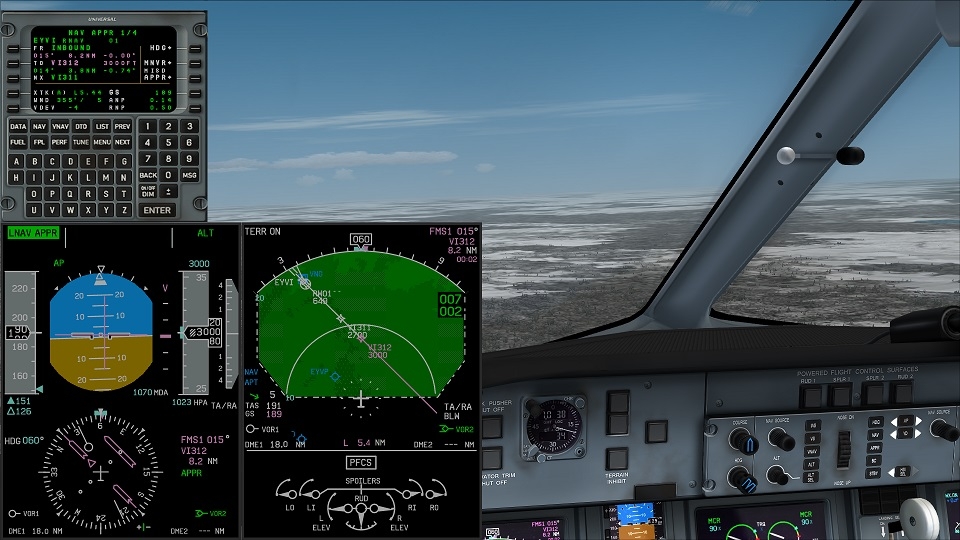
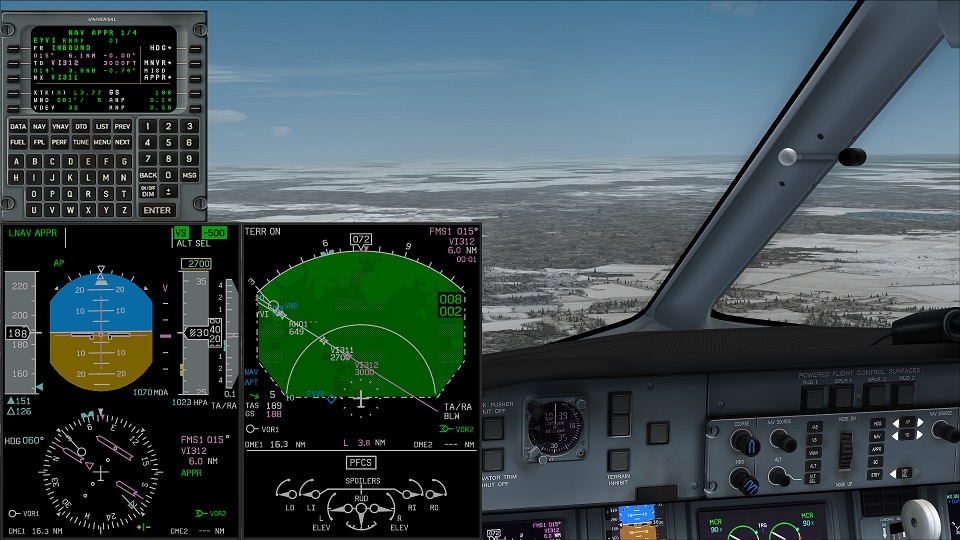
I have illustrated many of the flights so that I can use them for questions or to be able to write a tutorial on certain topics. So I can show with pictures how things are going for me. So far I have mostly had no problems with VNAV in the final approach, even without reducing the height in front of the FAF. It can of course be related to the procedures and modes before, but here I have illustrated the RNAV approach on Rwy 01 in EYVI. I fly by vectors away from the pre-planned routing and am then guided to the final approach with intercept heading. I first use VS to sink to the 2700 ft, in which the final approach begins, then poor VNAV beforehand and the VNAV path is flown from the FAF without lowering the altitude
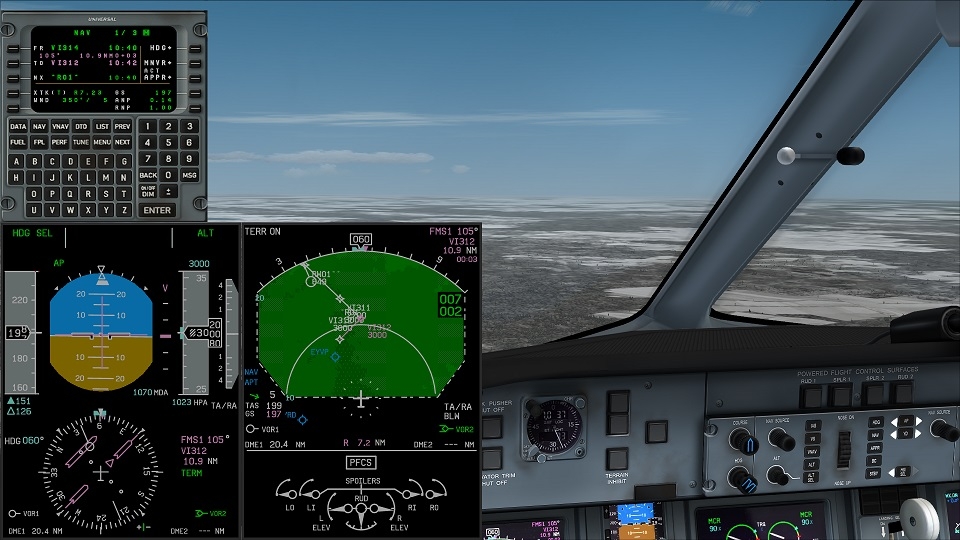
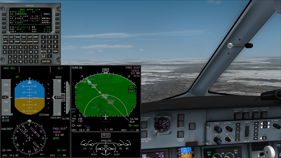
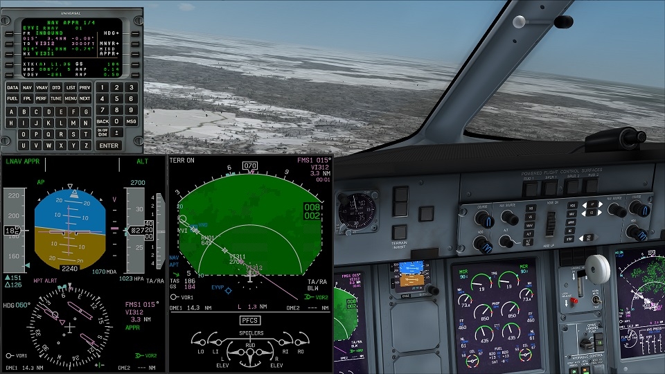
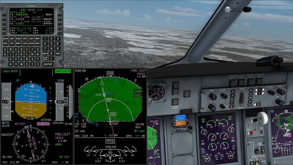
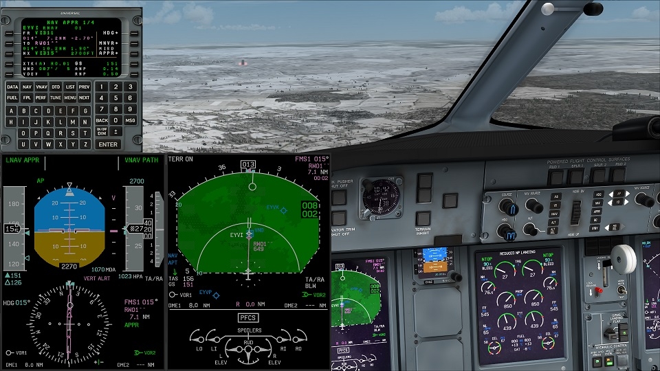
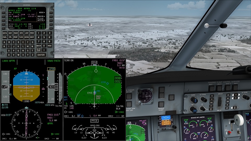
Flight with HDG and course towards Intercept Final Approach course
After clearance from ATC Activated Approach on NAV Page
Change from HDG to LNAV - Mode LNAV Approach becomes active
Descend via V/S from 3000 ft to 2700 ft
reaching 2700 shortly before intercept final approach course
with intercept armed/activated VNAV - VNAV PATH becomes active
shortly before FAF, Alt rest with VNAV PATH at 2700
when the FAF is overflight, the VNAV Path becomes active and follows the Final Approach Descend Path without lowering the altitude on the MCP beforehand
Is it same thing for a second approach after go around ?
Do I have to check on the WE, but had several GAs, just back to the beginning of the STAR (to test images or different flight modes), but then exactly like the first approach.
look last video vnav dont work even if vnav armed before FAF.
CYYZ toronto runway 5.
Few things:
GA AFTEK then RONTA. HDG mode. 3000 Ft. OK Fine.
RONTA is recommended 3000 Ft but if you are at 2000 Ft it would work.
At 2000 Ft, your descent starts at KERPU.
BEFORE KERPU you should have selected an altitude BELOW 2000 Ft otherwise you would not descend.
31'14" on your video it's too late so you diconnect the AP at 32'19" and you are 2.1 Nm before MUVOK still at 2000 Ft.
When you continue manually at a time your VS is 1500 Ft/mn (32'50"). Very dangerous as you shoud be stabilised between 1000 and 500 Ft at the latest. You should have initiated an other GA.
Why first try same altitude and no problem no lower altitude and plane descent ?
Sorry if I have to put it that way, but your flight implementation is pretty confused! After the holding, ATC will take you back to a point with a vector course, from which they will let you take the final approach again. From the holding it is advisable to fly with about 240 ° on the holding side in the downwind until you are sent clearly past R05Z / RONTA by ATC with e.g. 100 ° in the direction of the intercept final approach course. On the other hand, you are basically flying back the GA for the first time, you would fly into another aircraft that is flying the GA and then fly on the other side in the downwind. If you fly with HDG SEL, it contradicts itself to use DTO, why, because you even know where ATC wants to (real) take you. So you activate 3-4 x DTO RONTA, 3 times the plan collapses again, the approach is activated automatically and cearly again.
Only when you have been approved by ATC for the intercept of the final approach course (you are currently flying with the specified 100 ° in my example) do you activate the approach on the NAV Page, whereupon the approach baseline is shown shifted and all waypoints that are no longer required are deleted. You will therefore fly the approach from the FAF (according to Approach Plan R05z) cleanly. According to the approach plan, at RONTA you also fly at 3000 ft or higher and then start the Approach Desced Path at 7.5 NM before the Rwy. In the second attempt the heights for the path are missing in the ND. At KERPU, the NAV page shows -1000 ft VDEV again, so VNAV then also disengages. Why the heights are missing here according to the approach plan, I have no idea, but maybe it is also due to your flight behavior. You change the mode so often at the end (LNAV HDG INT and then when the aircraft turns in the wrong direction back to HDG SEL, then LNAV APPR again).
So if i understand plane don't descent the second approach because altitude constraints has disappeared.
So should i go Flp menu and arrival and add approach again ?
It is not about whether you are flying with ATC support, but rather practicing flight behavior like ATC would do and which makes overall sense in the execution of the flight. During your flight in the video, the system didn't even know what was going on, completely confused. Take a look at how often you edit DTO even though you are flying with HDG SEL! The approach, although far from the actual final approach (you're on the other side, i.e. Rwy 23) is activated several times automatically, changes to GA routing and in the end the routing is gone again, all completely unnecessary. Just fly, as I would have done and described, with HDG SEL, stay on the 3000 ft. If that really doesn't work again, you can set VNAV to RONTA when you are in the downwind, with the 3000 ft, which you are already flying, then it is at least programmed and should lead to the activation of VNAV PATH from 7.5 NM in front of the Rwy. Fly so far past RONTA in the downwind that you cut the final approach course with 100 ° at a sufficient distance from RONTA. Maybe I'll still be able to fly the approach with GA and try again today.
Why with last video plane is supposed turn right in the hold pattern after go around and and turn left ?
I must to go fms NAV/MNVR/holding DEFN and arm hold. 😀
Because i must to be at 4000 feet for missed approach and for the IAF i must to be at 3000 feet.
Perhaps i arm approach too soon.
So when i must to arm approach ?
Because i would like activate approach myself before IAF .
So I will probably not be able to fly today and probably next week, work and preparation for youth camps. ARM APR is not so relevant for the success of the approach in the FS. Here, among other things, only certain requirements are checked and you are offered the TUNE APR if you have not yet set a required frequency. In my charts (not up to date) I rise to 3000 ft in the GA. I have marked in red how I think that ATC will lead you back after a GA. Even if you had to go to a holding company first, you'd be redirected back then, then something would be transferred.
The holding is not a direct part of the GA, therefore it is not programmed in the GA routing, otherwise it would say "... direct to AVTEK and hold". If you are supposed to stick to AVTEK, you already have the reference to the charts, but you have to program it yourself in the FMS.
Let's just stick to one approach to solve problems or find solutions, otherwise you have to think again every time.