In any case, this will be doubtful, since we do not have official information regarding the real Dash...
I don't know why we have different data, but my Aerosoft and PMDG add 50 feet(in fplan mcdu/fmc) to crossing the threshold
P.S
ILS and non-precision approach. ICAO Pans-Ops states:
5.3.2 Determination of the descent gradient for a non-precision approach with FAF
The descent gradient (g) for a non-precision approach with FAF is computed using the equation: g = h/d. The values for h and d are defined as follows:
a) For a straight-in approach use:
d = the horizontal distance from the FAF to the threshold (Cat H, LDAH); and
h = the vertical distance between the altitude/height over the FAF and the elevation 15 m (50 ft) over the threshold.
@niksan29
Absolutely right regarding the theory for the 50 Ft at the threshold. This is a rule that should be followed even in visual approaches and the Toff and Ldg calculations are done with this parameter in mind.
However it appears that with the sim it depends of the way the approach was designed and also the parameters that I mentioned in my above post.
@niksan29 and @FraPre
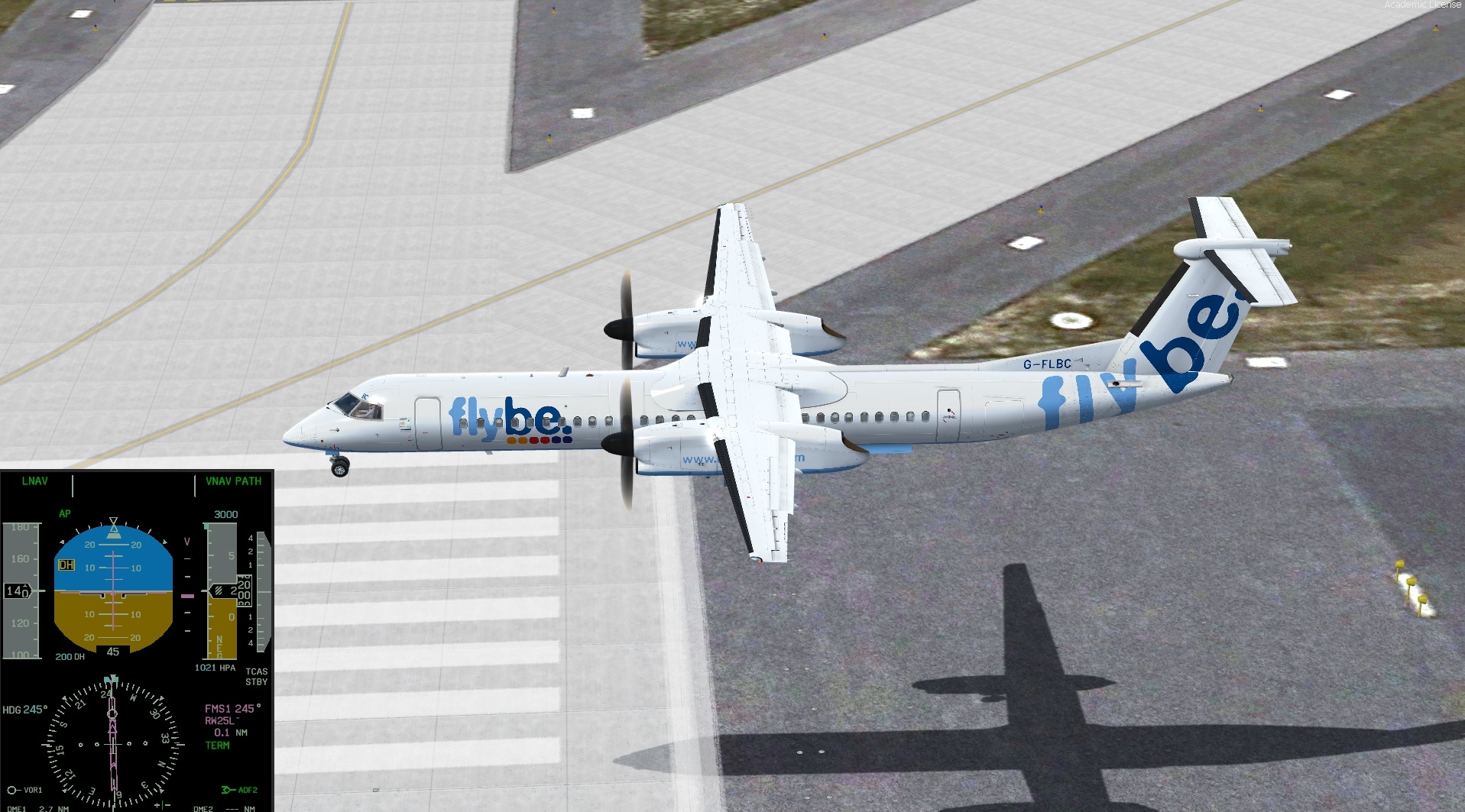
When I flew the EDDT RNAV Rwy 26R, the results were acceptable and now I decided to fly another approach:
EDDB RNP Rwy 25L
This approach is designed with LPV CAT 1 which is the lowest minima that we can have when flying this type of approach with, of course, the right equipment.
As we are not equipped for this, it was flown Baro-VNAV. Here are the figures:
8 Nm 2800' +50'
7 Nm 2430' same as shown on the chart
6 Nm 2090' -30'
5 Nm 1800' same as the chart
I missed the 4 nm check
3 Nm 1150' -10' RA 1010'
2 Nm 820' -20' RA 680'
At the minima (when I had a look) I was at 440' instead of 445' and the RA 280'
So when checked with the RA against the QNH altitude value the results were between 140' and 160' for an airport Elev of 156'. Not bad.
I decided to keep the A/P all the way down and, as you can see, the height at the threshold was 45'.
I did not enter the Vref and MDA as it was just for a quick test
I let the A/P all the way down and it disconnected itself at 10' (RA) just before the PAPI lights.
I cannot be affirmative but it looks that when an approach is designed by the FMS data provider it looks more precise if this approach is designed to be flown LPV CAT than LNAV/VNAV.
Keeping in mind that we have a sim costing only few $/€ instead of multi millions real aircrafts or full flight simulators it is as near as the real thing.
We are a bit away from my original post but I have made some progress understanding as the FMS approaches are flyable with our Majestic Q400.
I got some explanations from RW Q400 users: French Fire Fighters.
Their old Q400s have only LNAV and LNAV-VNAV Baro possibilities.
The new Q400s that they are getting now are LPV 200 Ft CAT I equipped.
Our Dash is not equipped (yet) with the latest LPV so we should do only LNAV-Vnav Baro.
I can live well with Baro-VNAV and thus land at 99% of airports in addition to the classic navigation methods in the approach. We will see whether SBAS / GBAS will even be implemented in the simulator, then the numerous add-ons have to be adapted.
Good evening, the 99% are more symbolic because I can't check what I'm really "allowed" to do with the Majestics. Every real aircraft is delivered with corresponding certifications (customer request), which show what the aircraft is capable of and is allowed to fly (RNP, RNP AR, Steep Approach, ...). The first Dash 8q400 only had B-RNAV equipment, our Dash here already has P-RNAV, but I am always missing a clear statement from the manufacturer about what the add-on aircraft can and should really do. But that only plays a real role in models that have been implemented as excellently as the Majestics Dash, the PMDG Boeings and the FS Labs A320. So the 99% stands for every RNP RNAV approach up to 0.30 RNP, with less I would not be sure and would leave it, i.e. everything that is RNAV RNP AR. The Majestics also has no equipment for the steep approach, so here too London City would fall below the one% (I have already flown the approach).
So there is almost always a legal way for me to land, and if not, that's how it is and I have to evade, that would also be real. An A320 captain friend of mine once wrote to me from the airport cafe that he is stuck, his plane is not coming, why? The main runway has an ILS, but was closed due to construction work. The parallel runway has no ILS, only an RNAV (GPS) and a VOR approach. The Airbus A320, an older model, did not have a GPS. ILS approach didn't work, RNAV (GPS) didn't work either and the clouds were too deep for the VOR approach.Good evening, the 99% are more symbolic because I can't check what I'm really "allowed" to do with the Majestics. Every real aircraft is delivered with corresponding certifications (customer request), which show what the aircraft is capable of and is allowed to fly (RNP, RNP AR, Steep Approach, ...). The first Dash 8q400 only had B-RNAV equipment, our Dash here already has P-RNAV, but I am always missing a clear statement from the manufacturer about what the add-on aircraft can and should really do. But that only plays a real role in models that have been implemented as excellently as the Majestics Dash, the PMDG Boeings and the FS Labs A320. So the 99% stands for every RNP RNAV approach up to 0.30 RNP, with less I would not be sure and would leave it, i.e. everything that is RNAV RNP AR. The Majestics also has no equipment for the steep approach, so here too London City would fall below the one% (I have already flown the approach).
So there is almost always a legal way for me to land, and if not, that's how it is and I have to evade, that would also be real. An A320 captain friend of mine once wrote to me from the airport cafe that he is stuck, his plane is not coming, why? The main runway has an ILS, but was closed due to construction work. The parallel runway has no ILS, only an RNAV (GPS) and a VOR approach. The Airbus A320, an older model, did not have a GPS. ILS approach didn't work, RNAV (GPS) didn't work either and the clouds were too deep for the VOR approach. Here, too, there are restrictions in day-to-day operation.
@FraPre you duplicate your post but it does not take the meaning away.
You are absolutely right and when I was flying we were landing about 99% (minimum) to the airports that we were going to even where the weather was (and is still) not always the best in winter: Ireland, Scotland, West France.
We did not have LNAV but only ILS, VOR, NDB and on some airports only gonio (the ATC was giving us QDM). On top of that as we were not a regular operator our minimas were higher than the large national airlines. I think, but I do not remember exactly, we had to multiply the minima by 1,6.
So with the equipment that we have with the Majestic Q400 if doing an ILS CAT II we could go down to 100 Ft, 200 Ft CAT I and LNAV-VNAV around 300 Ft (depending of the environment) which means that we can land most of the time.
LOWI is quite different than most airports due to its situation. I do not know the real place but I understand that sometimes there is quite a strong foehn effect and, usually, if there are strong winds, the cloud base is not too low and we could fly there.
Anyway, before to go you have the METAR and TAF and if you see that the forecast is going to be low clouds and bad visibility lower than your minima all day, you simply do not take off.
ILS are disappearing on small airports and are replaced by LPV due to maintenance cost but when you see the new Berlin, all four runways have ILS and are approved up to CAT III so the ILS have still some good years to live.
I did not want to double my contribution, but only responded to the 1% of the previous post. I had the feeling that concrete examples were really wanted here, but that is not the case. The 1% only covers the fact that you are not 100% sure.
Regarding the equipment aboard the Q400 you could say that 100% of the airports are accessible. Of course according that all the criteria such as lenght of rwy, altitude, temp, mass, weather, etc. are met.
I can't find any more about whether it's really just this one point, I don't know.
But maybe we are drifting away in the discussion. The Majestics Dash offers a certain level of navigational and flying options. The developers, and maybe you are one of them @niksan29 , have implemented a model for us, from which they must have had documents and perhaps also received technical support. The quality is still exemplary. What is not is not possible and actually it was only about what can and should you actually fly with the Dash. We have clarified that too, I think, and don't forget, we're here in the flight simulator at home, everything is fine. So if it sounded like criticism in the discussions, that's not the case. The Majestics Dash is still one of the best planes for the simulator.
Since the steep approach functionality is an "option" there is supporting data from the aircraft manufacturer which denotes how the system is implemented. It's easy to add a switch but what underlying paraments are affected and or must be in place which that switch is activated. WE do not have access to this technical information thus the reason it is not implemented. Granted the system on the outside based on the manual states what it does which is simply disabling certain functions of the EGPWS.
just wanted to clarify, you have official information: is there an intermediate altitude calculation in a real dash 8 for RNAV app?
and of course we know most other plans with mcdu/fmc can do this and these are standard procedures.
The same applies to FMS functionality as previously mentioned with respect to the fact that we modeled the FMS based on what we had available at the time. We have already put a lot of work into its development and actually had to re-write a majority of its code for the 64-bit platform. What other developers have done bears no relevance on what we do. If we find it feasible to improve on this feature we'll do so time permitting, and hopefully, we may be able to get some assistance from the Navigraph team on the issues of concern.
As always we welcome discussions on items/topics, there are times that we do not participate but we do read the topics to get a feel for their importance. Many of which are informative and interesting as different perspectives are shared based on everyone's interaction and knowledge of the respective real-world systems and procedures.
and hopefully, we may be able to get some
assistance from the Navigraph team on the issues of concern.
I really don't know how they can help you because their nav base is the same for everyone tools and aircraft, it's just a different format, but the data is identical.
let's hope you will have(with time) the necessary documentation and will be able to add this function(steep) as well as improve the VNAV system
P.S
and there is no criticism and claims to you, this is just what we noticed and are discussing it
Comments
It is that I understood as I used to fly there but now it is not used much more.
Tempelhof was something as well. Gone but not forgotten.
Yes, when it comes to closing airports with historical significance and history, Berlin is world class!
I don't know why we have different data, but my Aerosoft and PMDG add 50 feet(in fplan mcdu/fmc) to crossing the threshold
P.S
ILS and non-precision approach. ICAO Pans-Ops states:
5.3.2 Determination of the descent gradient for a non-precision approach with FAF
The descent gradient (g) for a non-precision approach with FAF is computed using the equation: g = h/d. The values for h and d are defined as follows:
a) For a straight-in approach use:
d = the horizontal distance from the FAF to the threshold (Cat H, LDAH); and
h = the vertical distance between the altitude/height over the FAF and the elevation 15 m (50 ft) over the threshold.
@niksan29
Absolutely right regarding the theory for the 50 Ft at the threshold. This is a rule that should be followed even in visual approaches and the Toff and Ldg calculations are done with this parameter in mind.
However it appears that with the sim it depends of the way the approach was designed and also the parameters that I mentioned in my above post.
@niksan29 and @FraPre
When I flew the EDDT RNAV Rwy 26R, the results were acceptable and now I decided to fly another approach:
EDDB RNP Rwy 25L
This approach is designed with LPV CAT 1 which is the lowest minima that we can have when flying this type of approach with, of course, the right equipment.
As we are not equipped for this, it was flown Baro-VNAV. Here are the figures:
8 Nm 2800' +50'
7 Nm 2430' same as shown on the chart
6 Nm 2090' -30'
5 Nm 1800' same as the chart
I missed the 4 nm check
3 Nm 1150' -10' RA 1010'
2 Nm 820' -20' RA 680'
At the minima (when I had a look) I was at 440' instead of 445' and the RA 280'
So when checked with the RA against the QNH altitude value the results were between 140' and 160' for an airport Elev of 156'. Not bad.
I decided to keep the A/P all the way down and, as you can see, the height at the threshold was 45'.
I did not enter the Vref and MDA as it was just for a quick test
I let the A/P all the way down and it disconnected itself at 10' (RA) just before the PAPI lights.
I cannot be affirmative but it looks that when an approach is designed by the FMS data provider it looks more precise if this approach is designed to be flown LPV CAT than LNAV/VNAV.
Keeping in mind that we have a sim costing only few $/€ instead of multi millions real aircrafts or full flight simulators it is as near as the real thing.
We are a bit away from my original post but I have made some progress understanding as the FMS approaches are flyable with our Majestic Q400.
JP
I got some explanations from RW Q400 users: French Fire Fighters.
Their old Q400s have only LNAV and LNAV-VNAV Baro possibilities.
The new Q400s that they are getting now are LPV 200 Ft CAT I equipped.
Our Dash is not equipped (yet) with the latest LPV so we should do only LNAV-Vnav Baro.
https://www.croatiaairlines.com/Croatia-Airlines-will-use-EGNOS-for-LPV-approaches
I can live well with Baro-VNAV and thus land at 99% of airports in addition to the classic navigation methods in the approach. We will see whether SBAS / GBAS will even be implemented in the simulator, then the numerous add-ons have to be adapted.
Good evening, the 99% are more symbolic because I can't check what I'm really "allowed" to do with the Majestics. Every real aircraft is delivered with corresponding certifications (customer request), which show what the aircraft is capable of and is allowed to fly (RNP, RNP AR, Steep Approach, ...). The first Dash 8q400 only had B-RNAV equipment, our Dash here already has P-RNAV, but I am always missing a clear statement from the manufacturer about what the add-on aircraft can and should really do. But that only plays a real role in models that have been implemented as excellently as the Majestics Dash, the PMDG Boeings and the FS Labs A320. So the 99% stands for every RNP RNAV approach up to 0.30 RNP, with less I would not be sure and would leave it, i.e. everything that is RNAV RNP AR. The Majestics also has no equipment for the steep approach, so here too London City would fall below the one% (I have already flown the approach).
So there is almost always a legal way for me to land, and if not, that's how it is and I have to evade, that would also be real. An A320 captain friend of mine once wrote to me from the airport cafe that he is stuck, his plane is not coming, why? The main runway has an ILS, but was closed due to construction work. The parallel runway has no ILS, only an RNAV (GPS) and a VOR approach. The Airbus A320, an older model, did not have a GPS. ILS approach didn't work, RNAV (GPS) didn't work either and the clouds were too deep for the VOR approach.Good evening, the 99% are more symbolic because I can't check what I'm really "allowed" to do with the Majestics. Every real aircraft is delivered with corresponding certifications (customer request), which show what the aircraft is capable of and is allowed to fly (RNP, RNP AR, Steep Approach, ...). The first Dash 8q400 only had B-RNAV equipment, our Dash here already has P-RNAV, but I am always missing a clear statement from the manufacturer about what the add-on aircraft can and should really do. But that only plays a real role in models that have been implemented as excellently as the Majestics Dash, the PMDG Boeings and the FS Labs A320. So the 99% stands for every RNP RNAV approach up to 0.30 RNP, with less I would not be sure and would leave it, i.e. everything that is RNAV RNP AR. The Majestics also has no equipment for the steep approach, so here too London City would fall below the one% (I have already flown the approach).
So there is almost always a legal way for me to land, and if not, that's how it is and I have to evade, that would also be real. An A320 captain friend of mine once wrote to me from the airport cafe that he is stuck, his plane is not coming, why? The main runway has an ILS, but was closed due to construction work. The parallel runway has no ILS, only an RNAV (GPS) and a VOR approach. The Airbus A320, an older model, did not have a GPS. ILS approach didn't work, RNAV (GPS) didn't work either and the clouds were too deep for the VOR approach. Here, too, there are restrictions in day-to-day operation.
@FraPre you duplicate your post but it does not take the meaning away.
You are absolutely right and when I was flying we were landing about 99% (minimum) to the airports that we were going to even where the weather was (and is still) not always the best in winter: Ireland, Scotland, West France.
We did not have LNAV but only ILS, VOR, NDB and on some airports only gonio (the ATC was giving us QDM). On top of that as we were not a regular operator our minimas were higher than the large national airlines. I think, but I do not remember exactly, we had to multiply the minima by 1,6.
So with the equipment that we have with the Majestic Q400 if doing an ILS CAT II we could go down to 100 Ft, 200 Ft CAT I and LNAV-VNAV around 300 Ft (depending of the environment) which means that we can land most of the time.
LOWI is quite different than most airports due to its situation. I do not know the real place but I understand that sometimes there is quite a strong foehn effect and, usually, if there are strong winds, the cloud base is not too low and we could fly there.
Anyway, before to go you have the METAR and TAF and if you see that the forecast is going to be low clouds and bad visibility lower than your minima all day, you simply do not take off.
ILS are disappearing on small airports and are replaced by LPV due to maintenance cost but when you see the new Berlin, all four runways have ILS and are approved up to CAT III so the ILS have still some good years to live.
JP
I did not want to double my contribution, but only responded to the 1% of the previous post. I had the feeling that concrete examples were really wanted here, but that is not the case. The 1% only covers the fact that you are not 100% sure.
Regarding the equipment aboard the Q400 you could say that 100% of the airports are accessible. Of course according that all the criteria such as lenght of rwy, altitude, temp, mass, weather, etc. are met.
In principle, this statement will be correct, no matter which instrument approach procedure fits and can be flown in the end.
It also works if there is no instrument approach at all as it is on many airports in Africa. So yes: 100%.
in my opinion: a percentage of what not allowed, we cannot perform
includes all the same:
1)a VNAV-guided descent, a navigation point with a defined altitude restriction is followed by one or more waypoints that have no restriction.
2)Steep Approach(and i wonder what is the difference between an aircraft admitted to this and
our Dash 8)
3)RNP RNAV approach with a value less 0.30 RNP
P.S
although the last two options are probably impossible to implement physically in the framework of the simulator.
since for the Steep Approach there is no influence on the physics model from the arm steep approach mode.
and for the RNP we always have an ideal satellite signal and no interference;)
I can't find any more about whether it's really just this one point, I don't know.
But maybe we are drifting away in the discussion. The Majestics Dash offers a certain level of navigational and flying options. The developers, and maybe you are one of them @niksan29 , have implemented a model for us, from which they must have had documents and perhaps also received technical support. The quality is still exemplary. What is not is not possible and actually it was only about what can and should you actually fly with the Dash. We have clarified that too, I think, and don't forget, we're here in the flight simulator at home, everything is fine. So if it sounded like criticism in the discussions, that's not the case. The Majestics Dash is still one of the best planes for the simulator.
Since the steep approach functionality is an "option" there is supporting data from the aircraft manufacturer which denotes how the system is implemented. It's easy to add a switch but what underlying paraments are affected and or must be in place which that switch is activated. WE do not have access to this technical information thus the reason it is not implemented. Granted the system on the outside based on the manual states what it does which is simply disabling certain functions of the EGPWS.
The same applies to FMS functionality as previously mentioned with respect to the fact that we modeled the FMS based on what we had available at the time. We have already put a lot of work into its development and actually had to re-write a majority of its code for the 64-bit platform. What other developers have done bears no relevance on what we do. If we find it feasible to improve on this feature we'll do so time permitting, and hopefully, we may be able to get some assistance from the Navigraph team on the issues of concern.
As always we welcome discussions on items/topics, there are times that we do not participate but we do read the topics to get a feel for their importance. Many of which are informative and interesting as different perspectives are shared based on everyone's interaction and knowledge of the respective real-world systems and procedures.
Cheers
THX @kroswynd
@FraPre
@kroswynd
yes, it really looks like a steep approach is just:
@kroswynd
I really don't know how they can help you because their nav base is the same for everyone tools and aircraft, it's just a different format, but the data is identical.")
let's hope you will have(with time) the necessary documentation and will be able to add this function(steep) as well as improve the VNAV system
P.S")
and there is no criticism and claims to you, this is just what we noticed and are discussing it