Losing "VNAV PATH", when passing every waypoint on descent.

Hi
I select the descent and approach, then go to the VNAV and get the TOD. Activate "ALT SEL" and VNAV, and all goes fine.
The trouble is, every time it goes over a waypoint, the VNAV cursor jumps to the top of the scale. Ihave to adjust the VS until it settles back again. Then it does the same thing at the next waypoint and every one after until we settle on the approach ILS.
I have been using this for years and know how to do the setups, but I can not work out why this happens. Iy is no huge seal as I can make the descent with the VS quite easily, but it would be nice if this can be fixed.
Any ideas?
John Khan
Comments
Hi,
Don't hit ALT SEL! When in VNAV the plane will hold all constraints automatically so you do not need and shouldn't use ALT SEL while in VNAV.
Rgds
Reinhard
Hi,
but that shouldn't be the cause of the problem. If I am cleared for a certain height, I have to screw it in and also define it as a limit in the dash so that I do not accidentally sink below it. Until then, all restrictions will be observed. I myself have no problems in this regard. VNAV remains correctly active even when passing a waypoint. Can you please tell us in more detail, from which height you want to sink where? Make a picture of the routing, the VNAV page and the ND (location of the TOD).
OK Thank you both.
I will try without selecting ALT SEL on the descent, with VNAV on, and see what happens.
A long time ago when I first got the Dash I went through the original tutorials and I'm sure it said to select the dcscent altitude, ALT SEL and VNAV when the descent path appears on the PND.
If it happens again I will take pics.
Cheers
john
"A long time ago when I first got the Dash I went through the original tutorials and I'm sure it said to select the dcscent altitude, ALT SEL and VNAV when the descent path appears on the PND."
This is also correct, because with the dash you set the limit with the ALT SEL in order not to fall below a previously approved height. At Boeing and Airbus e.g. if this is not necessary, the screwed-in height is sufficient.
I have done another flight from Melbourne to Launceston and taken several pics. The same thing happened.
I tried with and without ALT SEL and it made no difference. I notice that the initial point appears twice in the plan. I tend to delete the first, the one that appears before the actual approac. I'm not sure if this makes any difference.
Rather than sending heaps of pics. What sort did you want?
Hello John,
DON´T delete anything, this will disengage the former VNAV selection!
And don´t use ALT SEL - as aua668 mentioned already before.
Just set the ALT on AFCS 500 ft below your current altitude (without ALT SEL)
Hope this helps
Rainer
Hi there,
I don't understand what ALT SEL is supposed to cause problems here that some strictly reject it. This is nonsense. I fly the Dash almost exclusively and have never had such problems. As John writes, he has problems with and without ALT SEL, which shows that there must be another cause. The pictures should show us the routing itself as FMC (we can also fly it around), your VNAV page after setting the VNAV parameters, the PFD / ND before TOD, afterwards and the whole thing again at the next navigation point, where you are always have problems.
This happens to me, too, but then it's usually a case of poor programming. Do you enter the waypoint altitudes yourself? If so, care should be used to not end up with unattainable vertical paths. If you enter an altitude restriction of let's say 10.000ft and tell VTO to take you there, VTO will not only form a descent path there, it will also try to fill out the vertical path for the entire rest of the flight plan after that WP. So say you tell it to be at 10.000 at WP1 and then WP2 has an automatic (a published) altitude restriction of 4000ft and it's just five miles behind WP1. If you've told your VNAV to maintain vertical path at a certain vertical speed, as you do, it will give up when passing the first WP because it cannot maintain the demanded vertical path to the next one and the programmed vertical speed at the same time. The VNAV page in the FMS should state something to the tune of "TARGET VS LOW" at that point to tell you it would need to descend much faster to make that next restriction and that you're on your own from here as far as figuring that mess out.
As far as ALT SEL, I make it a habit to press it every single time I dial up an altitude, regardless of what mode I'm in. Just to be on the safe side, it's just part of the motion of setting an altitude for me. That's the way it would work in the many, many aircraft that do not require you to arm the altitude seperately anyway...
OK Thank you Rainer.
I will try it again without deleting anything.
One more thing, if I may.
When setting up the VNAV descent, without any ATC. Which altitude should I select for the descent?
How I do it now is: If an ILS approach. I select the IP altitude, usually around 3000ft. Then go to the ILS.
If an RNAV or visual approach, I select the altitude of the Final point for the approach,
I do enter other altitudes on the flight plan descent, if they show on the charts. (Navigraph Charts Desktop)
I really appreciate the help on this forum.
Hallo John,
I don´t fly the Dash at the moment, but if I remember right, you needn´t set an ALT for RNAV(RNP) or ILS APCH.
I give you an excerpt of my procedure for an RNAV (RNP) APCH:
RNAV(RNP) APCH (RNAV & VOR-DME APCHs need a co-located DME & are basically GPS APCHs)
Without ATC set the ALT (with ALT SEL) to the IAF-ALT, when you are there then ARM then select the programmed APCH as the routine goes/as you used to do it.
Just try it and build up your own routine!
Hope this helps
Rainer
Hello John, you should always program VNAV so that you get the TOD correctly calculated. To do this, the system must know which is the first height restriction. As Rainer said, all waypoints in the FMC must be compared with the charts as part of the approach preparation. Usually the start of the STAR / Approach Transition has the first limitation. VNAV must take this into account, otherwise the calculated TOD does not take existing restrictions into account! To make this clear, I wrote it down using the example of a flight from TXL to FRA. The KERAX25N is flown on the Rwy 25R. This includes some the following defined restrictions according to the map, which can also be found in the FMC:
KERAX = AT 10000 ft, DF411 AT or ABOVE 9000 ft, DF411 AT or ABOVE 5000 ft, NIBAP (as IF) AT 5000 ft. When I now stop the simulator while cruising (I am at VOR MAG) and program the VNAV, it happens following. Don't be surprised, my charts are from 2014. Some of the height restrictions are no longer available in newer charts.
If I take KERAX as a reference point, the TOD is calculated in 93 NM shortly after TAMEB, if I take DF411, if it is 126 NM before SOLVU, if I take DF422, if it is 155 NM behind GED, also if I take IF NIBAP , In the last two cases, you can clearly see that I would still fly at KERAX with my cruising altitude FL240, the limitation 10000 ft above KERAX is not taken into account. So I always have to take the first limitation for VNAV programming on my flight path to get the TOD displayed correctly and to start the descent in time. Without ATC you should do it the same way, because in this case I fly as published in the charts. The given heights have a reason. With ATC it becomes more unlikely to use VNAV for the Descend, because requirements are arbitrary and cannot be planned. For the final approach with an RNAV approach, of course, it fits again.
I am no longer saying anything about ALT SEL.
So, I ended the flight again and captured everything in pictures. As you can see here in the PDF, everything worked perfectly (operating actions were mainly limited to the VNAV test). Maybe you can also illustrate your pictures from the flight Melbourne to Launceston in a similar way, because your problems have to come from somewhere.
Hello FraPre,
good demonstration for the procedure!
And same would have worked without setting the altitude for IF DF422 at 5000ft in the AFCS; just setting it for example 500ft below your current ALT of 24000ft (in your case), no?
Rainer
Hello Rainer,
technically, that would certainly work as long as I don't set the 500 ft below with ALT SET. To start VNAV, you need a different height in the AFCS, 500 ft is enough, after that VNAV stays on the profile if I don't define a limit (ALT SET). Even beyond DF422, the dash would go down without a limit, at least if no RNAV approach is defined. In this case, a level flight with pitch hold should follow briefly before the FAF, because the AFCS requests an additional confirmation that it can follow the VNAV final approach profile. With a NON RNAV approach programmed in the FMS, the dash should also continue to drop in profile at the FAF, as long as it has clues. But I doubt that this is the correct way to proceed. I haven't tried that yet, because it's not realistic anyway. The (ALT SET) has been the "discussion topic" in this thread often enough. If ATC, and without ATC clearance, no change in height is released to a height, this is turned in the AFCS and the limit is set with ALT SET in order not to accidentally drop below this height. That's what this function is for! The autopilots of other planes work differently, since the turned-in altitude is the limit without having to arm it again separately, so there would be no discussion at all.
If I do not use ALT SET, I have to make sure that I level up when reaching the approved height and then maintain the height. Completely unnecessary and dangerous. However, if you have any real indications that this will be handled as you write, I am happy to take note of it.
My example was not very realistic, usually there is an ATC e.g. in this case to 10,000 feet free, in order to then decide for yourself whether you should fly the following transition at all and to what height you should continue to sink, and which direction to fly until you are released for the intercept of the extended approach baseline. These subsequent changes in altitude would almost always be flown with VS instead of VNAV. However, an instructed change in altitude is always anchored with ALT SEL, regardless of which AP mode I use to fly it. The final approach is an exception later, but that's not the point here.
As such, John's problem remains unsolved.
Hallo Frank,
thank you for your explanation and clarification.
Maybe someone else - perhaps "jpgmultimodal", an Old-School Ex-RW-tubeliner-Pilot from which I learned a lot! - can chime in for the pending problem?
Best wishes
Rainer
Hallo John,
after re-read again some Flight-Protocolls for RNAV or ILS-APCHs I suggest the following:
Fly your example flights or at least the STARs and approches again with:
1. ALT set to DH/DA in AFCS AND ALT SET!!! (as Frank emphasized)
2. Don´t delete anything in the approach programming as I explained in my previous post.
Supplement 1 to what I´ve posted previously:
CAVE: After on FMS-VNAV page the descent is programmed, ARM APPR on NAV 1page and VNAV is selected on AFCS, any change on VNAV page will disengage the former VNAV selection (i.e. the active FPL) and AFCS mode will change to HDG SEL (therefore ALWAYS tracking the HDG to current CRS as backup!) and PITCH HOLD.
Supplement 2:
There is a peculiarity in the Q400 FMS programming - a so called "Appr Type Designator". I give you again an excerpt of a protokoll I´ve done to explain:
See attatched pdf.
If/when you do the rest allright for the approach I assume everything will go well.
Good luck
Rainer
Hi,
One comment from my side: FraPe is ABSOLUTELY right with his procedures of ALT SEL. My recommendation was a little bit short and therefore misleading:
I understood out of the first post of John, that he selects the altitude of the first point with an altitude constraint and activates ALT SEL, which of course will level-off at the first point.
So for flying without ATC the procedure described by FraPe is perfect and with ATC you select ALT SEL anyhow for every descent altitude given to be sure to level-off at the demanded altitude.
Rgds
Reinhard
Thank you to all who posted.
I have tried several more flights using different procedures. I know how to program the descent with VNAV, and there is no trouble with the TOD and starting down.
No matter what I do, the descent path keeps on jumping to the top of the scale, when we go over the next waypoint, and the "PITCH HOLD" appears, whether ALT SEL is on or off.
I have always selected 1800 fpm, as the rate of descent for VNAV. This came from the original tutorial from years ago.
When the PITCH HOLD appears and the cursor jumps to the top of the scale, it seems that rate is too much, and I see the vertical speed is actually showing 1200 to 1400 fpm.
So I have selected 1200 fpm for the rate, but the same thing happens when it gets to the next waupoint, the PITCH HOLD comes on and it now is showing about 800 fpm!!
I do have many pics regarding all this.
I think, from now, I will use the VNAV and adjust it with VS to re-capture the VNAV PATH. It is no huge deal, and frankly, is good to actually do something, rather than have the computers do almost everything!!
Thanks again
May we get a route or a video to see what it may be that is not working in your favor?
Hi
I will try, but I have never made a video. Maybe I can take some screen shots as I go along. I'll have a look to see what I can do. Here are a couple to see if it works.
Hi,
Just one question, as I found no hint in your description: Did you also arm the approach on the NAV page?
Rgds
Reinhard
I think there is a problem with understanding the approach here. You fly to YCFS, where there is no STAR, i.e. your routing leads you directly to the airport, here the CFS VOR. For the landing you programmed an RNAV approach Rwy 21 with transition via the IAF CFSND. The IAF CFSND is stored at 5500 ft, your last point of the CFS routing you obviously provided with 10,000 ft as a reference height so that you can sink out of the cruise accordingly using VNAV. The comparable VOR approach, which starts at CFS, is 5000 ft, which is 5000 ft lower than how you fly. The distance from CFS to CFSND is 15.8 NM, which is good enough to decrease from 10,000 ft to 5500 ft. Why VNAV gets out of here is not yet clear to me, but in this phase I would no longer sink with VNAV, but in preparation of the approach with VS, in order to then fly with VNAV again from CFSND via the RNAV approach. You would be real but certainly very different, by vectoring to CFSND at a more favorable angle, as you come, the VOR approach really offers itself better.
So please try to enter the target height at CFS 7000 ft for VNAV, or fly the VOR approach, then with 5000 ft at CFS. Can you take a picture of your VNAV page in the FMS?
That is just for understanding the approach there itself, the preparatory work for the approach, as mentioned by aua668, I have now left out, have no direct meaning for VNAV
https://www.airservicesaustralia.com/aip/current/dap/CFSGN02-158_07NOV2019.pdf
https://www.airservicesaustralia.com/aip/current/dap/CFSVO03-158_07NOV2019.pdf
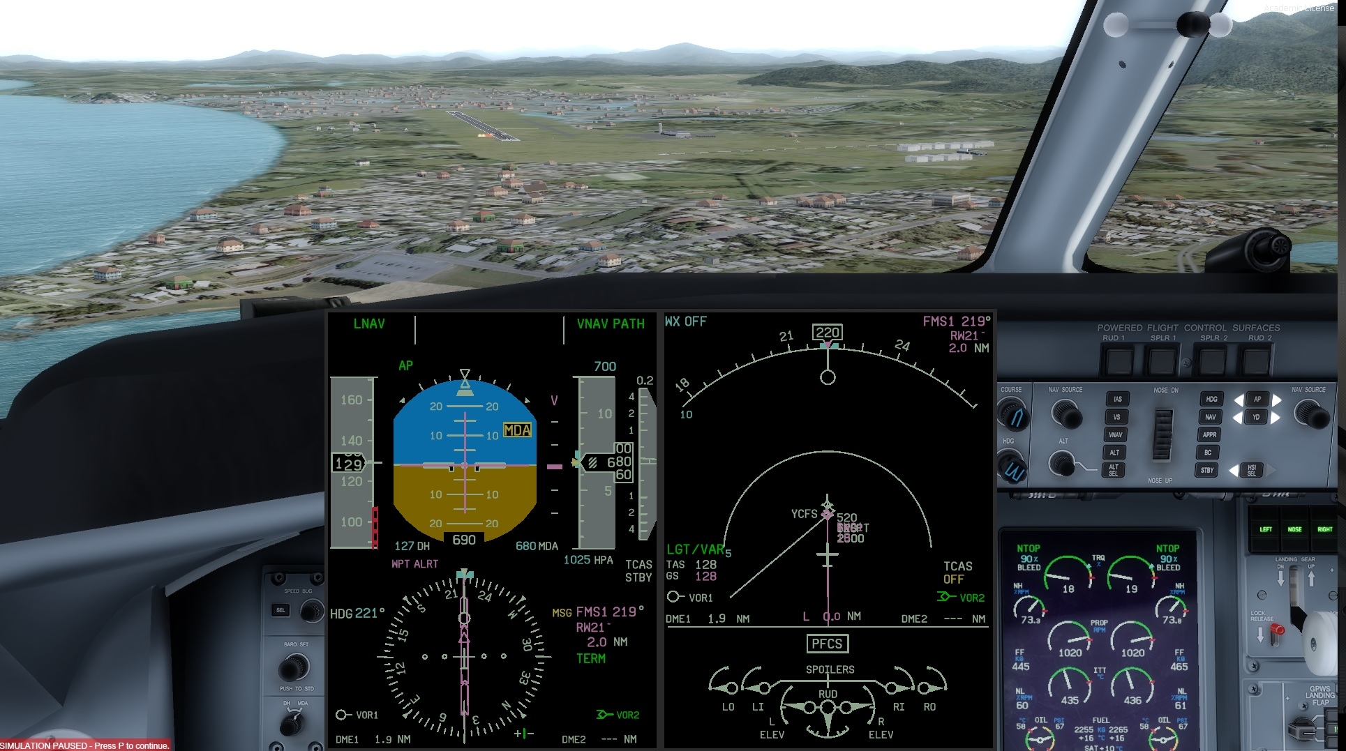
Good news for the dash, bad news for you, John. The whole thing works fine, just why not with you. Here is an illustrated test flight from YPMQ to YCFS, as in your example from the south via the VOR CFS
Hi,
To Rainer: I am from the old school, true as I started to fly in the sixties but I had only a CPL with IFR and did not hold an ATPL ; so mostly flew as co-pilot. I am not expert on FMS. I try to learn a bit the new technics but I still rely mostly on maths.
This post is very interesting and I think I found out something which could be of interest.
To John: The way that you fly this approach (YCFS - RNAV Z Rwy 21) does not seem right as it is not the way it is designed. You should not arrive vertical 10 000 Ft and rejoin the IAF for the RNAV. If you want to fly this approach RNAV you should join from one of the three IAF at 5500 Ft and not with such a narrow angle.
The way that you arrive, I suppose from the SW you should fly a VOR Rwy 21 and I would personnally prefer the VOR Z as you would work in distance instead of time (VOR Y) on the outbound leg.
You can fly this VOR Z approach "overlay" with the FMS and it would descend all the way from the vertical CFS VOR using the LNAV VNAV.
Now, something else: to be at 10 000 Ft over the VOR is not right, you should be at 5 000 Ft over the VOR to go on the outbound leg. If for some reason (ATC) you are at 10 000 over the VOR, you descend, when instructed, to 5 000 Ft in the hold.
As I said I am not an expert on VNAV but I believe that if you try to descend from 10 000 Ft to 2 500 Ft in 8 Nm the FMS does not like it and you are not going to be popular with your PAX either as you are going to have a VS of about 3000 Ft/mn. At 180 Kt (GS) with a 3° angle your VS should be around 900/1 000 Ft/mn.
I did this approach VOR-Z Rwy 21 overlay using LNAV and VNAV and it worked fine. Here is the picture taken at the minimum just before disconnecting the A/P:
Something else quite important, check that you have the correct QNH.
I know that ALT SEL has been mentioned quite a few times and should not be used during the procedure. It is only when you have a constraint mostly by ATC and they clear you to a certain FL or ALT that you use the ALT SEL or to level before intercepting an ILS The ALT SEL is found only, as far as I know, on DASHES.
Regards,
JP
OK. Thank you everyone.
I appreciate all the advice but think it's good to leave this now.
I have no idea why this happens and, as I said, I can complete the descent and approach quite well using the VS. If there is an ILS, that works fine also.
I will try out the test flight and keep trying a few things as I go.
Hi,
One idea for the different behavior of VNAV between the approaches of John and FraPre. Are you both on the same version of the Dash? As far as I remember from another discussion about AIRAC database formats, FraPre is using the FSX Pro version - correct? John, which version are you using (FSX/P3D 64-bit)? One of the comments of Majestic in that discussion was, that they have rewritten the FMS for the 1.020a version.
Rgds
Reinhard
majesticsoftware.com/forums/discussion/comment/2124
Yes, FSX without the actual Update.
Hi,
I diid now the same flight as FraPre with the 64-bit Q400 P3D 4.5 latest HF and with the actual AIRAC. And the same result: VNAV worked perfectly down all the waypoints (although with CFS at 10.000ft this is tough).
Rgds
Reinhard
Hello,
Even that I did not like the idea of being at 10 000 Ft over CFS I tried the same procedure than FraPre and Reinhard, the YCFS RNAV-Z Rwy 21, IAF CFSND.
I am with the PRO Q400 P3Dv4.5 latest patch and AIRAC up to date. No weather.
It works even better than expected, altitudes matching the Rwy 21 distances as per the book (Jeppesen 03/2020).
Here is as it looks at MDA:
Being so pleased with the result I decided to carry on as low as possible with the A/P. Of course it is absolutely illegal (RW) but for the sake of the experiment I went down as low as 25 Ft, in fact we are a bit low on the path as we should be 50 ft at the threshold.
Anyway here is the result:
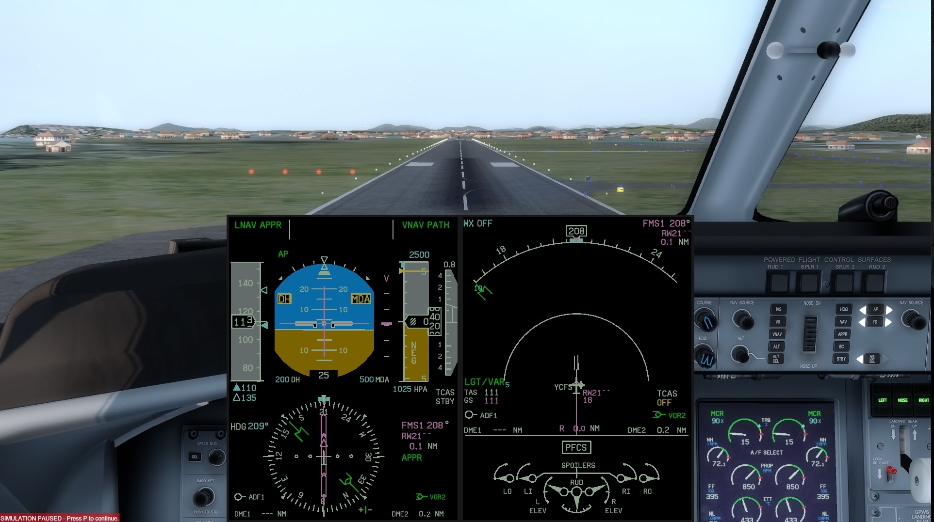
Everything was ready just before CFS and I did not touch a thing except the PL and the HDG bug. I know, I forgot about the CL and I kept the A/F ON but the idea was to demonstrate that the LNAV/VNAV is working perfectly.
However I found out, in different situations, that there are some strange behaviour with the LNAV as, sometimes it turns the opposite way for a few seconds and comes back to the right direction afterwards. It'll be the subject of another post.
Once more well done Majestic crew.
Regards,
JP
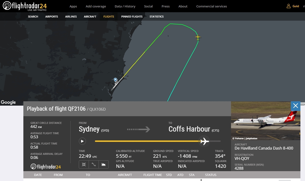
The way it is done by Quantas: